Posted 24 June 2010

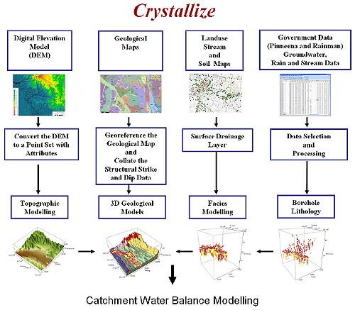
Figure 1: Data processing flow chart for constructing a 3D conceptual hydrogeological model of a catchment.
This project is funded under the Raising National Water Standards Program administered by the National Water Commission and will contribute to improved environmental water management and planning through a set of tangible, science-based outcomes.
Measuring components of the water cycle and quantifying geological, vegetation and anthropogenic impacts on the rate of movement of water through a catchment requires the collation and analysis of vast quantities of temporal and spatial data. How these data are presented influences our interpretation and then how we manage surface water and ground- water.
This project demonstrates one approach to data management and interpretation (Figure 1). In particular, it has shown the value of using interactive graphs and it highlighted the benefits of analysing catchment groundwater data in 3D. This is important for communicating complex information to all stakeholders.
It has also demonstrated the value of collecting a comprehensive suite of water chemistry parameters for quantifying the coupling between the rivers and underlying aquifers and for delineating the zones of mixing within an aquifer system.
The project focused on a small catchment within the Murray-Darling Basin called Maules Creek near Narrabri. However, the methodologies can easily be scaled to catchments of any size.
New Data Processing, Visualisation and 3D Geological Modelling Methodologies
A library of Mathematica® functions, called Crystallize, has been developed for the:
Mathematica is a registered trademark of Wolfram Research, Inc.
Crystallize is a set of Mathematica notebooks that contains descriptions of the data processing steps and scripts for manipulating, analysing and plotting the data. These notebooks capture all the details about the methodologies used by the project team and form a guide for Catchment Management Authorities and state water departments. The 3D geological models can be used as the conceptual framework for catchment water balance studies, or to plan drilling targets.
Integrating Groundwater Chemistry and Isotopes
The chemical composition of groundwater samples has successfully been used to aid in the understanding of the hydrogeological processes in the aquifer system. Non-reactive natural tracers such as stable isotopes of water (2H and 18O have been used to identify different sources of water (i.e. river recharge, mountain front recharge and diffuse recharge). Reactive chemical species such as oxygen (O2), nitrate (NO3-) and iron (Fe2+) also provided clues to the sources of water; in addition they provided information about water quality issues related to these different water sources.
More importantly, the extensive sampling and analysis of water quality data have provided insights into how water quality changes are related to hydrogeological stresses and changes in groundwater usage.
This project has demonstrated that incorporating groundwater chemistry into hydrogeological investigations is essential and stresses the need for continuous and rigorous monitoring of water chemistry, because it provides information about how changes in water management will affect both surface water and groundwater quality in the long term.
Namoi Catchment Management Authority, Cotton Catchment Communities CRC, and the Cotton Research and Development Corporation.
The National Water Commission is responsible for driving progress towards the sustainable management and use of Australia's water resources under our blueprint for water reform - the National Water Initiative.
Groundwater level monitoring data recovered at the end of 2019 from Mystery Road at Breeza on the Liverpool Plains reveals a direct connection between the Gunnedah Formation unconsolidated sands and gravels and the underlying Permian coal measures. The connection is provided by the old deep channel of the Mooki River that cuts down into the coal measures. This is a crucial piece of evidence to be incorporated into groundwater models.
What are the effects of fire on water underground? Let’s think about what happens on the surface, and translate that to what is likely to happen to the subsurface.

The effects of tidal forces on groundwater might be less apparent to us than their effects on the ocean, but they’re just as important.

Dr Oliver Knox has brought together information from some of the industry’s researchers conducting work oncotton-producing soils.
Groundwater research at ANSTO has provided crucial information to support the management of finite groundwater resources appropriately and sustainably—answering questions about groundwater recharge, groundwater age and dynamics, the interaction between surface water and groundwater and salinisation.