Posted 5 September 2007
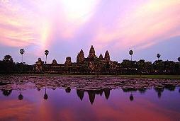
Angkor Wat, Cambodia
The Khmer kings who created the world's most extensive medieval "hydraulic city" surrounding Cambodia's famed Angkor Wat were the architects of its eventual environmental collapse, says an Australian, Cambodian, French and American research team.
This new revelation published in the Proceedings of the National Academy of Science, supports a disputed hypothesis by French archaeologist Bernard-Philippe Groslier, who 50 years ago suggested that the vast medieval settlement of Angkor was defined, sustained, and ultimately overwhelmed by over-exploitation and the environmental impacts of a complex water-management network.
A succession of monarchs ruled the Angkor area from about 800 AD, producing the architectural masterpieces and sculpture now preserved as a World Heritage site. By the 13th century the civilisation was in decline, and most of Angkor was abandoned by the early 15th century, apart from Angkor Wat, the main temple, which remained a Buddhist shrine.
Groslier surmised that a network of roads, canals and irrigation ponds established between the 9th and 16th centuries proved too vast to manage. He argued that extensive land clearing for rice fields supporting up to a million people living beyond Angkor's walled city produced serious ecological problems, including deforestation, topsoil degradation and erosion.
Prior to Groslier's research, archaeologists had concentrated their explorations on the massive temples built between the ninth and 13th centuries as monuments to the power and wealth of the Khmer kings. The rest of the region remained carpeted with vegetation, with few remnants of the ancient civilisation visible to the human eye at ground level.
Undeterred, the Frenchman commissioned an ambitious topographic mapping program in the 1960s to investigate the wider area. However, his vision was halted due to its ambitious scale, the impacts of the civil war and the devastation caused by the Khmer Rouge and Pol Pot's regime meant.
Latter-day archaeologists therefore disputed Groslier's view because he was unable to support his hypothesis with empirical data about the landscape beyond Angkor's central temple complex.
Using modern day aerial photography and high-resolution ground-sensing radar, the international researchers studied an area of nearly 3,000 square kilometres, confirming Groslier's hypothesis by correlating their images to existing maps, topographic data sets and supporting information from extensive ground-based archaeological investigations.
The size of the complex is comparable in area to the sprawling suburbia surrounding Sydney. It was a vast and extensive settlement that encroached on the natural environment to the north as it grew, according to Damian Evans, the study's lead author and deputy director of the University of Sydney's Greater Angkor Project.
In what is the culmination of 15 years' work, the team has discovered over 1,000 manmade ponds and at least 74 more temple sites in the Angkor region, revealing ruins covering an area of 1,000 square kilometres. Mr Evans said the temples not only had a religious function but were centres of taxation, education and water control that reveal much about the everyday life in medieval Angkor.
"We can see that the land used there was very intensive, so whenever the settlement expanded over this vast area, basically they tore down the existing vegetation cover and remodelled the landscape into a very artificial landscape.
"So it's quite clear that they were having some kind of very significant impact on the environment over a large, very, very large area.
"Whether the severity of the problems that that caused and whether they were able to deal with those problems is another issue which we're trying to get out through more targeted and focused studies, such as excavations," Evans says.
"We also find evidence of village temples, around which these occupation mounds were clustered in many cases, and we see evidence of ponds as well, which would've been used as a water resource during the dry season, as well as evidence of a vast water management system designed to trap water coming down from the hills in the north.
"So really what we can see is a very dense urban fabric stretching between and far beyond these huge temples at Angkor."
The new study's radar images were acquired from NASA via an airborne imaging radar (AIRSAR) data instrument capable of accurately reconstructing surface structures through cloud cover.
"The instrument can produce high-resolution images detecting surface structures as small as 20 cms in height and distinguish very subtle differences in surface vegetation and soil moisture," says Professor Tony Milne from the School of Biological, Earth and Environmental Sciences, a UNSW co-author of the breakthrough study.
"This was of particular use in uncovering the archaeological landscape at Angkor. The distinctive spatial patterning of features manifests itself primarily in slight variations in topographic relief. This also influences the amplitude or 'brightness' of the radar signal returned to the sensor."
"Both the topographic relief and the surface brightness can be helpful in identifying the possible location of former roads, canals and rice fields," says Professor Milne. "When excavations were carried out, they prove to be the site of a canal or temple moat".
The Angkor temples have suffered extensive destruction by nature and pillaging by looters during three decades of warfare and revolution in Cambodia. And local authorities are grappling with the problem of how to preserve the ruins within the temple precinct from increasing numbers of visitors.
Less than 10,000 people ventured to Angkor in 1993, when it was added to UNESCO's World Heritage list. Since then, with Cambodia becoming accepted as a "safe" destination, tourism has boomed. Angkor Wat is now one of southeast Asia's leading attractions and the government is expecting three million visitors in 2010, many of whom will head to the temples.
Funding for this research was principally from the Australian Research Council but also from the Mekong River Commission, the University of Sydney, l'Ecole Francaise d'Extreme-Orient, the Authority for the Protection and Management of Angkor and the Region of Siem Reap, the Carlyle Greenwell Bequest, and the Iain A. Cameron Memorial Travel Grant Fund, and the NASA, CSIRO, UNSW co-sponsored PACRIM Radar Project.
Links:


Professor Andy Baker features in American Water Resources Association ‘Water Resources Impact’, September 2020 edition.

The Connected Waters Initiative (CWI) is pleased to welcome Taylor Coyne to its network as a postgraduate researcher. If you’re engaged in research at a postgraduate level, and you’re interested in joining the CWI network, get in touch! The CWI network includes multidisciplinary researchers across the Schools of Engineering, Sciences, Humanities and Languages and Law.

The Grand Challenge on Rapid Urbanisation will establish Think Deep Australia, led by Dr Marilu Melo Zurita, to explore how we can use our urban underground spaces for community benefit.

On the 21 August 2020, CWI researchers made a submission to the National Water Reform Inquiry, identifying priority areas and making a number of recommendations as to how to achieve a sustainable groundwater future for Australia.

Results published from a research project between the Land Development Department (LDD) Thailand and UNSW has demonstrated how 2-dimensional mapping can be used to understand soil salinity adjacent to a earthen canal in north east Thailand (Khongnawang et al. 2020).