Posted 25 February 2008
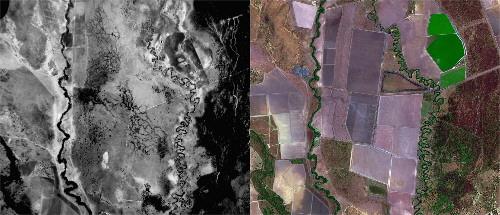
Pictures show a comparison of the same floodplain wetlands in 1972 and 2004 on the lower Macquarie River floodplain, upstream of Warren: the Macquarie River is represented by the irregular line running from the bottom to the top of the images with a distributary channel running on the right. Most the rest of the area was floodplain in 1972 but was developed primarily for irrigated cotton by 2004 (regular shaped blocked areas). Green area in the top right represents a newly planted crop.
A landmark study by a team at the University of New South Wales has mapped more than 2,000 km of levee banks, channels and storages on the floodplains of the Macquarie Marshes, an internationally significant wetland listed under the Ramsar Convention.
The study identified 338 km of levees, 1,648 km of channels, 54 off-river storages and 664 farm dams on the floodplain of about 4,300 square kilometres.
Professor Richard Kingsford, an author of the new report, says: "This is the first time such an extensive study has been done for any river in the Murray-Darling Basin and the extent of development is surprising as it is making a significant impact on the river and its ecology."
The study identified that earthwork structures (levees, channels, storage reservoirs and farm dams) were spread throughout the floodplain of the Macquarie River between Warren and Carinda on the lower Macquarie River.
This floodplain is characterised by flood-dependent vegetation, including river red gums and reed beds. Most of the development has occurred in the southern part (72%), small central area and a small northern part of the Macquarie Marshes, areas with irrigation development. There are also a few smaller low level earthworks in other parts of the Macquarie Marshes, including the Nature Reserve where a bypass channel takes water quickly through the middle of the reserve.
Celine Steinfeld, a member of the research team, says: "The use of satellite imagery, combined with detailed mapping should now allow governments throughout the Murray-Darling Basin to identify the locations of such structures."
The study also identified that most of the earthwork development occurred between the 1980s and 1990s, with ongoing development after governments of the Murray-Darling Basin agreed to a cap of diversions from the rivers of the Murray-Darling Basin.
The combination of reduced flows as a result of river regulation and the cutting off of flows by channels and levees has had considerable impact on floodplain trees, killing many hectares, according to Celine Steinfeld. At one point, levee banks and channels have constricted the floodplain from about 14km in width to about 2.5km.
The study also analysed how government policies and guidelines for floodplain works had been implemented. In the early 1980s, the NSW government identified floodways designed to remain unimpeded so that flows could pass downstream. The study found that these guidelines had been breached. There were 101 km of levees, 368 km of channels and 16 off river storages within the floodways. Revised guidelines in 2006 shifted the guideline boundaries so that 88km of levees, 338 km of channel and 8 off-river storages were within the revised floodways.
Professor Kingsford claims while this is a difficult area for policy and regulation, there has been no assessment by government on whether the structures are legal or may be diverting water from environmental flows despite almost a decade of discussion.
He said there was evidence collected by the NSW Department of Environment and Climate Change that some of the environmental flow destined for the Macquarie Marshes in November 2005 had been diverted into irrigation storages. He also believes that earthworks outside the irrigation areas need to be assessed to determine their effects on vital flows for the renowned Macquarie Marshes.
There is widespread development of such earthworks on the floodplains of most of the rivers of the northern part of the Murray-Darling Basin. "Without proper assessment, there is no way that governments will be able to estimate the take of water from the rivers of the Murray-Darling Basin," says Professor Kingsford.
"This is water that is essentially free and having a significant impact on the environment. Now we have shown it is possible to identify structures rigorously, there should be no excuse for governments not to do the necessary work for all rivers in the Murray-Darling Basin to make sure that we at least know the other half of the story when it comes to the degradation of our rivers. The Federal Government's $10 billion rescue package for the rivers of the Murray-Darling Basin has to address the issue of floodplains".
Media contact:
Bob Beale, mobile 0411 705 435
Links:

Professor Andy Baker features in American Water Resources Association ‘Water Resources Impact’, September 2020 edition.

The Connected Waters Initiative (CWI) is pleased to welcome Taylor Coyne to its network as a postgraduate researcher. If you’re engaged in research at a postgraduate level, and you’re interested in joining the CWI network, get in touch! The CWI network includes multidisciplinary researchers across the Schools of Engineering, Sciences, Humanities and Languages and Law.

The Grand Challenge on Rapid Urbanisation will establish Think Deep Australia, led by Dr Marilu Melo Zurita, to explore how we can use our urban underground spaces for community benefit.

On the 21 August 2020, CWI researchers made a submission to the National Water Reform Inquiry, identifying priority areas and making a number of recommendations as to how to achieve a sustainable groundwater future for Australia.

Results published from a research project between the Land Development Department (LDD) Thailand and UNSW has demonstrated how 2-dimensional mapping can be used to understand soil salinity adjacent to a earthen canal in north east Thailand (Khongnawang et al. 2020).