Posted 25 January 2011
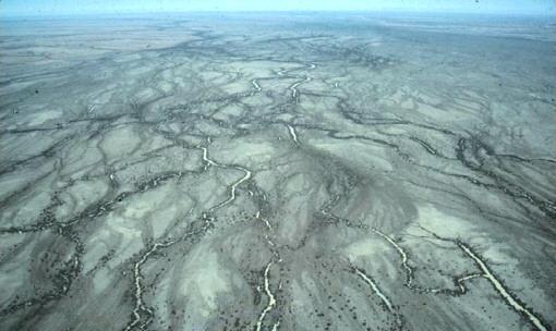
The channel country of Cooper Creek, with its large muddy floodplain and anabranching network of multiple river channels: what about the water beneath?
New research published by a team of researchers from UNSW, ANSTO, and UOW has provided new insight into some of the shallow groundwater systems of central Australia that were previously very poorly understood.
Little is known of the extent, quality, or connectivity of the shallow groundwater systems known to exist in most of the interior of the continent.
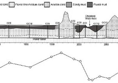
Work conducted in the channel country of Cooper Creek, in the eastern part of the Lake Eyre Basin, has revealed that beneath the dense muddy floodplains there lie coarse quartz sands of ancient river beds where a large, shallow, mainly saline aquifer can be found.
While this shallow groundwater system is largely disconnected from the multiple river channels that spread across the large floodplains above, chemical analysis suggests they provide the only effective means of aquifer recharge.
Composed of relatively impermeable thick muds, the floodplains of the channel country prevent infiltration of fresh surface water through to the water table below.
However during large flood events, when surface flows can scour the mud bases from river channels and expose the underlying sands, fresh water is able to flow into the aquifer.
The effect and location of these fresh water recharge events is limited. For the most part, they form isolated lenses of freshwater - like islands - surrounded by groundwater with much higher salinities.
This research is a first step in understanding the water resources available to a part of the country where water is known to be scarce.
Ongoing research in this area includes investigating the origin and transport of salts in the rivers of the lake Eyre Basin, the timing and magnitude of shallow groundwater recharge events, and trying to explain the remarkably quick transformation to saline groundwater in this region.
For more information, refer to the Key Concepts in Geomorphology Vignette and the publication in Journal of Hydrology.
Links and further information

Professor Andy Baker features in American Water Resources Association ‘Water Resources Impact’, September 2020 edition.

The Connected Waters Initiative (CWI) is pleased to welcome Taylor Coyne to its network as a postgraduate researcher. If you’re engaged in research at a postgraduate level, and you’re interested in joining the CWI network, get in touch! The CWI network includes multidisciplinary researchers across the Schools of Engineering, Sciences, Humanities and Languages and Law.

The Grand Challenge on Rapid Urbanisation will establish Think Deep Australia, led by Dr Marilu Melo Zurita, to explore how we can use our urban underground spaces for community benefit.

On the 21 August 2020, CWI researchers made a submission to the National Water Reform Inquiry, identifying priority areas and making a number of recommendations as to how to achieve a sustainable groundwater future for Australia.

Results published from a research project between the Land Development Department (LDD) Thailand and UNSW has demonstrated how 2-dimensional mapping can be used to understand soil salinity adjacent to a earthen canal in north east Thailand (Khongnawang et al. 2020).