Posted 29 October 2015

Drilling and coring equipment in action.
A new research paper published in the Australian Journal of Earth Sciences reports on a detailed subsurface study was conducted in the southern Liverpool Plains. At Cattle Lane, 20 km west of Quirindi, a core extracted from the upper 30m of sediment was analysed in detail. The material consists of a vertical mixture of sand and clay with shells interspersed. The shells were identified as inland freshwater species and provide evidence of a frequent shallow and muddy freshwater environment at various times throughout the last 114,000 years.
Microscopic analysis of the sediment grains also found evidence of dust deposition throughout time. The dust was blown in carrying salt crystals and mixed with local clay sediments. It is this salt that has caused salinization of the shallow groundwater throughout many areas of the Liverpool Plains.
Dating of the core sediments revealed that the material has been accumulating at a rate of 0.25m per thousand years, with the bottom of the sediments dating back to 114,000 years. By comparing our upper sediment dates to nearby studies on preserved pollen, we have identified a 2.4 million year gap in sedimentation between the deeper sediments and this upper 30m.
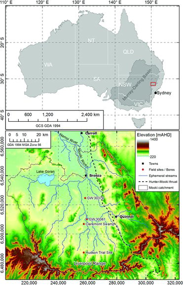 Topographic map showing the location of the study area (around borehole GW30061) in the Liverpool Plains.
The missing millions of years of sediments highlight the complex process of deposition and erosion in fluvial systems. Meandering rivers leave behind a complex stacked sedimentary sequence, and this has to be understood if we are to predict the impacts of climate variability, mining, gas production and irrigated agriculture.
When doing Environmental Impact Assessments we need to know at the local scale if there is high vertical hydraulic connectivity associated with well-connected vertically stacked sand-filled paleochannels, or if there is a hydraulic barrier due to a mixture of in-channel sands, near-bank silts and floodplain clay deposits. Knowing the local sedimentary sequence is the only way to determine whether the high saline shallow groundwater, associated with the dust deposits, will be mobilised by erosion or a change of the water balance.
The complexity of the sedimentary sequence from this core, and other CWI research findings throughout the catchment, challenge the widely accepted geological framework used to manage groundwater resources in the Liverpool Plains. Current groundwater models being used to forecast the impact of mining and agriculture on the groundwater resources use an overly simplistic two layer model of the paleovalley-filling sediments. Such simple models cannot be used to accurately model local impacts.
To achieve better assessment of local scale impacts, future groundwater models need to incorporate more geologically realistic aquifer architecture (palaeochannel belts, floodplain deposits, etc.). Modelling local scale impacts will become more important as we juggle the impacts of climate variability, agriculture, coal mining, and coal seam gas developments throughout the Namoi River catchment in north-eastern New South Wales.
Find out more about this research by reading the full paper, ‘Late Cenozoic paleovalley fill sequence from the Southern Liverpool Plains, New South Wales – implications for groundwater resource evaluation’, online in Australian Journal of Earth Sciences at: http://www.tandfonline.com/doi/full/10.1080/08120099.2015.1086815

Professor Andy Baker features in American Water Resources Association ‘Water Resources Impact’, September 2020 edition.

The Connected Waters Initiative (CWI) is pleased to welcome Taylor Coyne to its network as a postgraduate researcher. If you’re engaged in research at a postgraduate level, and you’re interested in joining the CWI network, get in touch! The CWI network includes multidisciplinary researchers across the Schools of Engineering, Sciences, Humanities and Languages and Law.

The Grand Challenge on Rapid Urbanisation will establish Think Deep Australia, led by Dr Marilu Melo Zurita, to explore how we can use our urban underground spaces for community benefit.

On the 21 August 2020, CWI researchers made a submission to the National Water Reform Inquiry, identifying priority areas and making a number of recommendations as to how to achieve a sustainable groundwater future for Australia.

Results published from a research project between the Land Development Department (LDD) Thailand and UNSW has demonstrated how 2-dimensional mapping can be used to understand soil salinity adjacent to a earthen canal in north east Thailand (Khongnawang et al. 2020).