
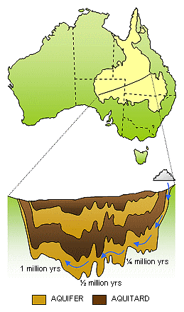
Great Artesian Basin structure showing groundwater flow and age (after Bentley et al., 1986)
Water moves through the oceans, continents and atmosphere as it circulates in the hydrologic cycle. Water is continuously added and removed from the volumes contained at each of these stages of the cycle. The average amount of time a water molecule spends at a particular stage during its journey through the hydrologic cycle is known as the residence time. The residence time is calculated by dividing the total amount of water at that stage by the rate at which water is added and removed from it.
Water moves through some stages of the hydrologic cycle relatively quickly, and at other stages the rate of flow takes place over very long periods of time. For example, while the residence time of water in the atmosphere is about 11 days and the average residence time in lakes and rivers is about 2 weeks, the water in the oceans has a residence time of around 40,000 years.
The circulation of groundwater resources can occur over both very short and very long time scales.
The Great Artesian Basin in central and eastern Australia is one of the largest confined aquifer systems in the world, extending for almost 2 million square kilometres. By analysing the trace elements in water sourced from deep underground, hydrogeologists have been able to determine that water extracted from these aquifers can be more than 1 million years old.
By comparing the age of groundwater obtained from different parts of the Great Artesian Basin, hydrogeologists have found it increases in age across the basin. Where water recharges the aquifers along the Eastern Divide, ages are relatively young. As groundwater flows westward across the continent, it increases in age, with the oldest groundwater occurring in the western parts.
This means that in order to have travelled almost 1000 km from the source of recharge in 1 million years, the groundwater flowing through the Great Artesian Basin travels at an average rate of about 1 metre per year.
However, since the extraction of large amounts of groundwater from the Great Artesian Basin began in the late 1800s, there has been a decrease in the pressure of the confined aquifer. This has caused a drop in the quantity of water yielded by bores dug for agriculture and industry, as well as reducing the output from naturally occurring springs that support fragile ecosystems.
Understanding the rate of recharge and flow is essential for the sustainable management of this important groundwater resource. If the extraction of groundwater exceeds the rate of recharge, this could have serious implications for the resource and the ecosystems and industries that depend on the Great Artesian Basin.
Sources:
Bentley et al., 1986. Chlorine 36 dating of very old groundwater. 1. The Great Artesian Basin, Australia. Water Resources Research, 22:1991-2001.
Deming, D., 2002. Introduction to hydrogeology. McGraw-Hill, New York.
Mudd, G.M., 2000. Mound springs of the Great Artesian Basin in South Australia: a case study from Olympic Dam. Environmental Geology 39: 463-476.
Links:

Facts curated by Dr Landon Halloran, Dr Gabriel Rau and Dr Martin Andersen from UNSW Sydney. Graphics and design by Anna Blacka from UNSW Sydney. Funded by the NSW Research Acceleration and Attraction Program to support the Australian Government National Collaborative Research Infrastructure Scheme.

This resource introduces aquitards and aquicludes, and discusses some of the cutting-edge approaches used to understand the movement of water and contaminants through the ground.

Having a geologically realistic conceptual site model is important for characterising hydraulic connectivity throughout aquifer systems, and modelling water transit times.

The use of heat as a tracer promises to be an excellent alternative to traditional assessment methods for quantifying exchange between surface water and ground water.

There are two common mistakes often made when calculating how much groundwater storage levels have changed.