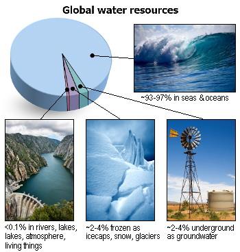
According to most estimates, about 94-97% of all water on earth is seawater held in the oceans. All freshwater resources occur in the remaining 3-6%. Around half of this is frozen in snow, glaciers and icecaps, about half is found underground as groundwater and a fraction of a percent (less than 0.1%) is surface water found in rivers, lakes, reservoirs, the atmosphere and all living things.
Water is constantly circulating between the oceans, continents and atmosphere in a system called the hydrologic cycle. This circulation is driven by a combination of the energy from sun, geological processes and gravity.
Water from the oceans and land is transported into the atmosphere by evaporation. Water is also transferred to the atmosphere from vegetation by evapotranspiration.
Water returns to the earth's surface by precipitation. On land, some of this water flows over the surface in streams and rivers into lakes, reservoirs and the oceans. The remainder infiltrates the land surface and percolates into aquifers. Some water can enter aquifers directly from the oceans. The energy of the earth's interior drives the geological processes that influence formation, influx, storage, movement and exsurgence of groundwater. Groundwater can be a source of surface water on land and can flow into the oceans.
Understanding how water on land, in the oceans and in the atmosphere is connected in the hydrologic cycle is essential for the successful management of our water resources. Through these connections, factors affecting one part the cycle can influence the entire system.
Sources:
Department of Land and Water Conservation (DLWC), The Water Cycle, NSW Department of Land and Water Conservation, Sydney, 2000.
Winter, T. C., Harvey, J. W., Franke, O. L. and Alley, W. M., 1998. Ground Water and Surface Water, A Single Resource. U.S. Geological Survey Circular 1139.
Facts curated by Dr Landon Halloran, Dr Gabriel Rau and Dr Martin Andersen from UNSW Sydney. Graphics and design by Anna Blacka from UNSW Sydney. Funded by the NSW Research Acceleration and Attraction Program to support the Australian Government National Collaborative Research Infrastructure Scheme.

This resource introduces aquitards and aquicludes, and discusses some of the cutting-edge approaches used to understand the movement of water and contaminants through the ground.

Having a geologically realistic conceptual site model is important for characterising hydraulic connectivity throughout aquifer systems, and modelling water transit times.

The use of heat as a tracer promises to be an excellent alternative to traditional assessment methods for quantifying exchange between surface water and ground water.

There are two common mistakes often made when calculating how much groundwater storage levels have changed.