Posted 19 June 2020
Introduction
In all the work carried out as a part of the EIS and the various responses to the EIS, the analyses provided to the PAC and the IESC and the descriptions of the conceptual model used as a basis for the groundwater model of the alluvium; there is no mention of the presence of the old channel of the Mooki River. This is disturbing for many reasons. How can it have been missed by so many? Whatever the reasons, the reality of the presence of this channel is highly significant as it reveals direct connection between the alluvial sand and gravels at the base of the channel and the coal measures. Such a close connection has major implications for the practicality of mining the Hosskinson and higher coal seams at Watermark.
The Old River Mooki Channel
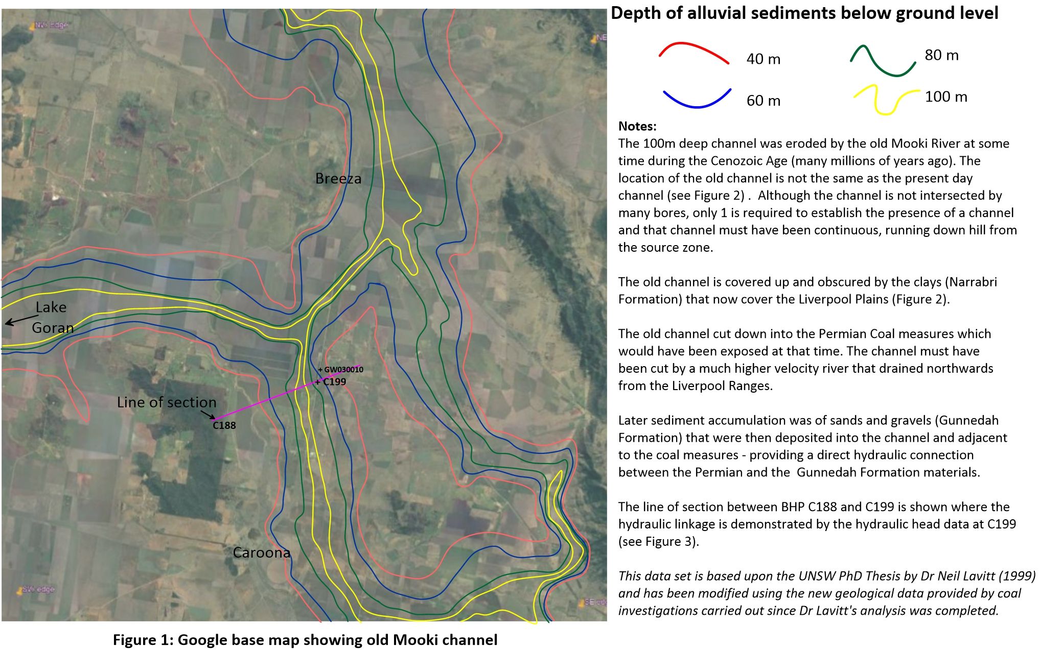
The old channel of the River Mooki was eroded out at some time in the Cenozoic Era. The wider channel was possibly eroded out in the Paleocene, but the narrow deeper channel possibly results from uplift to the south that was caused by the volcanics associated with the Liverpool Ranges during the Eocene. The presence of the deeper channel was identified by Dr Neil Lavitt during his PhD studies culminating in his thesis presented in 1999. Dr Lavitt examined the evidence from all the available coal investigation bores, water investigation bores and private drilling data held by the various agents NSW Government. Figure 1 is based on a figure from Lavitt’s PhD Thesis but has been updated to include information from the available investigations carried out for proposed coal mines since the mid 1990s. The data from the BHP investigation at the Caroona prospect immediately to the south of the Watermark prospect has been particularly helpful.
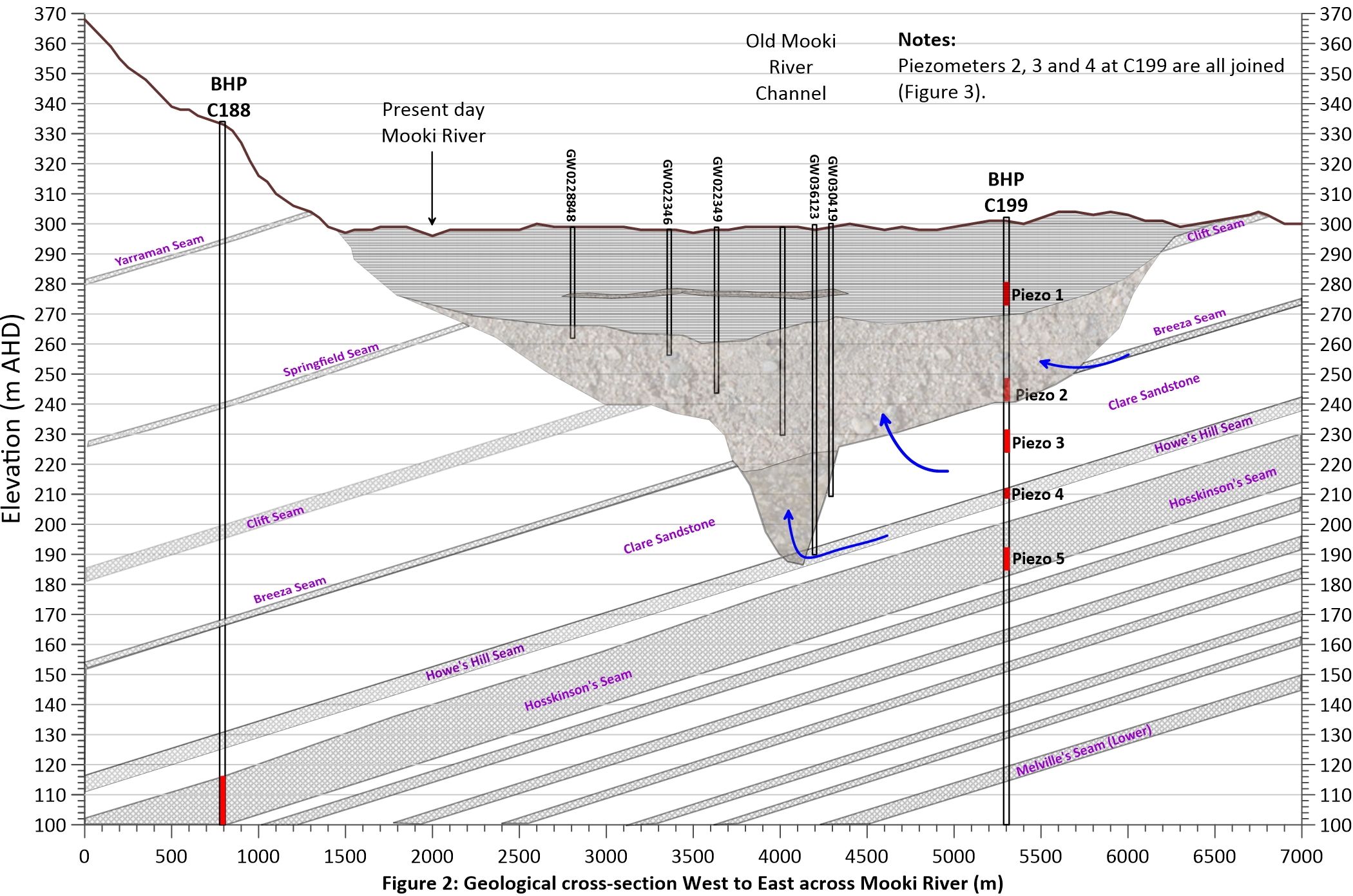
A geological cross-section has been prepared using the deep drilling data from BHP at sites C188 and C199 (Figure 1) and has been supplemented by drilling data available from the WaterNSW web site. The section is presented in Figure 2.
The BHP data clearly identifies the coal seams present in the Permian deposits and as they have a fairly uniform dip which is approximately to the west, Figure 2 shows what the deposits look like approximately along strike.
BHP drilled 5 separate boreholes at Site C199 and the depths of the piezometers in these 5 bores are shown schematically in Figure 2. It can be seen that the horizons targeted by BHP were as follows:
Piezometer 1 - The upper high clay content deposits often referred to (incorrectly) as the Narrabri Formation are shown by horizontal bars in Figure 2.
Piezometer 2 – The higher sand and gravel content deposits beneath the clays constitute the aquifer that provides groundwater supplies. The depth of the channel on the cross section is confirmed by the lithological log of Borehole GW036123 (WaterNSW web site).
Piezometer 3 – Targeted the Permian Clare Sandstone
Piezometer 4 – Targeted the Howe’s Hill Coal Seam
Piezometer 5 – Targeted the Hosskinson’s Coal Seam. This seam forms a regional marker in the Gunnedah Basin and is a major coal resource as it has a thickness of between 10 and 15 m.
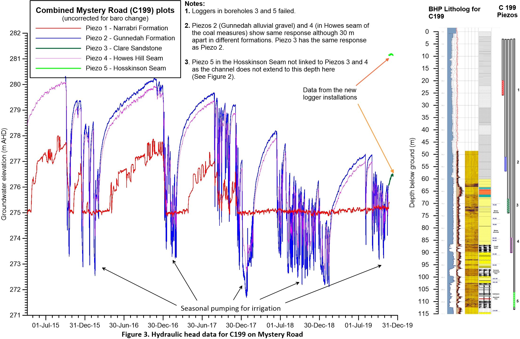
The hydraulic heads in these 5 piezometers were being recorded every 6 hours by BHP before the investigation by BHP was terminated. The loggers were left in the boreholes and the extensive network of investigation sites was passed to the NSW Government. Data from the loggers installed in the bores was eventually extracted in 2019 and is shown in Figure 3.
Unfortunately, Loggers in Piezometers 3 and 5 failed before they were removed from the bores, however data from the remaining loggers has been invaluable in developing a better understanding of groundwater at this site. It is noted that this sort of data was particularly recommended by the IESC in their initial reviews of the Watermark EIS. It is also noted that, although the logger installed in Piezometer 3 (The Clare Sandstone) had failed, the water level in this piezometer had earlier been shown to lie between Piezometers 2 and 4.
The lithology at C199 is clearly shown in Figure 3 where the geophysical logs obtained by BHP at this site are shown. Again, it can be seen from the schematic of the piezometers (far right of Figure 3) that the piezometers clearly target the 5 horizons previously identified.
The 4.5 years of 6-hourly measurements shown in Figure 3 reveal that the sands and gravels of the Gunnedah Formation (Piezometer 2) react in the same way as the water levels in the Howe’s Hill Coal seam (Piezo 4). These piezometers are connected hydraulically and can not be considered to be hydraulically isolated – as incorporated in all the conceptual models underlying the regional groundwater modelling. The water levels in the Howe’s Hill coal seam respond to groundwater abstraction for irrigation. It is noted that the water level in the Hossinson’s coal seam (Piezometer 5) does not respond in the same way and has a hydraulic head some 5 m higher than the overlying coal seam (due to the failure of the logger in Piezometer 5, only a small amount of data is available but this is consistent with earlier reports). The explanation for this can be seen in Figure 2 where it is evident that, at this site, the channel cut into the Permian by the Old Mooki River does not penetrate as deep as the Hosskinson’s Coal Seam.
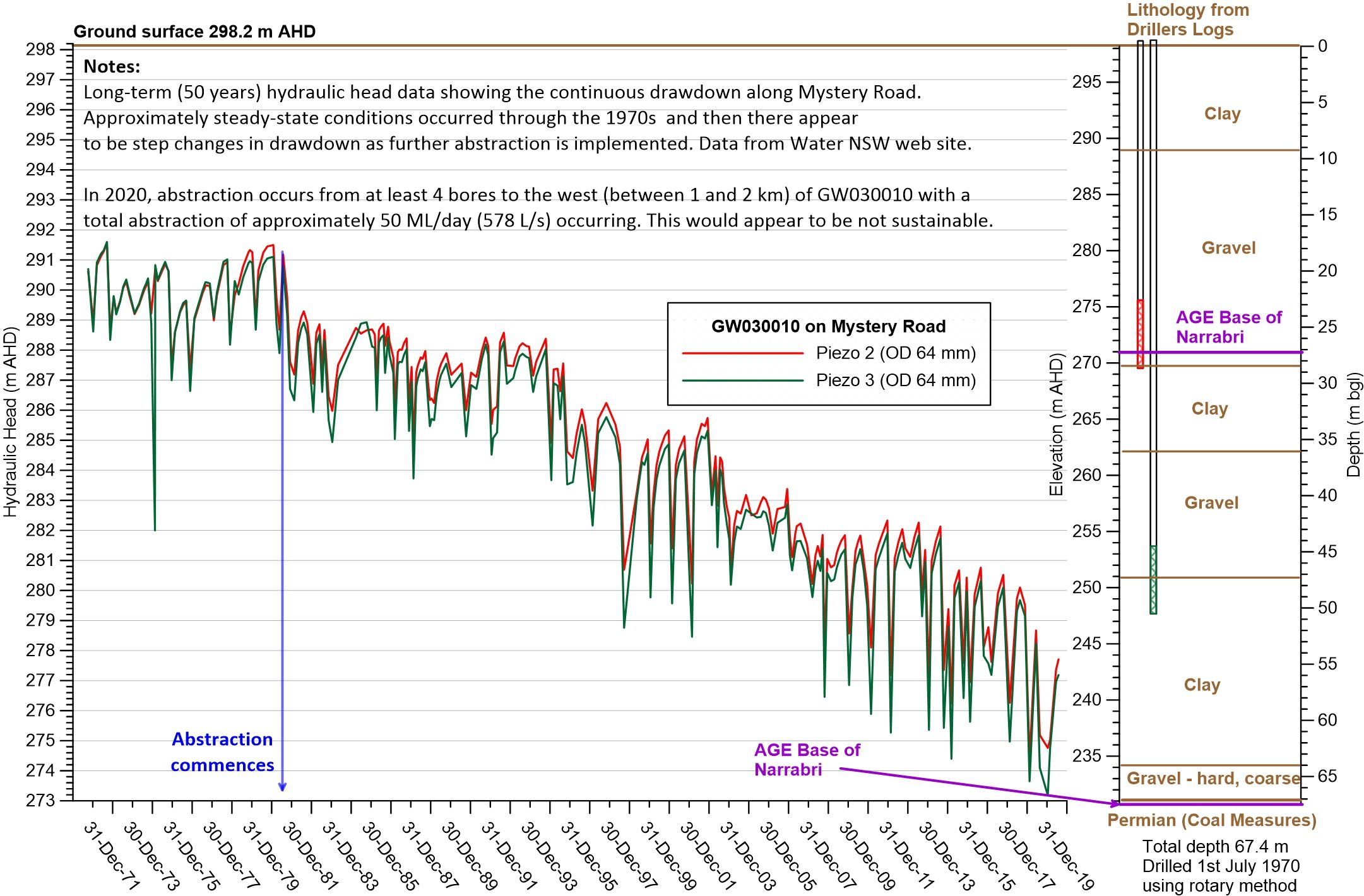
Figure 4 shows a 50-year record of observations at GW030010 (approximately 500 m north along Mystery Road from C199). It is evident that long-term significant drawdown is occurring in the sands and gravels in response to significant (50 ML/day) abstraction from boreholes drilled into or close to the Old Mooki River Channel. Two important observations can be made here:
The first is that water must be being abstracted from the Howe’s Hill Seam and the Clare Sandstone (both in the Permian) by these bores. Therefore, in a similar situation, groundwater abstraction from the Permian must impact the alluvial water resource.
The second is that this level of abstraction is not sustainable in the long term, whether for irrigation or for mining.
The latter point is important in that any new abstractions from the alluvial system to support the proposed mining operations must not be relied upon.
The fairly consistent drop in groundwater levels shown in GW030010 is surprising as it shows that the recharge that is considered to have occurred in the wetter periods of the 1970s and 1980s did not stop the overall decline. It is possible that without this recharge, the decline would have been even greater. Since 2012, the rate of decline in groundwater levels has increased.
The general fall in groundwater levels along Mystery Road and up into Breeza is similar to that shown for GW030010 – indicating that the cone of drawdown caused by abstraction is very extensive. In passing, this is what was anticipated when the values for specific storage were investigated.
The Old Mooki Channel and Watermark
Data for any new piezometers installed by Shenhua are not available at this time and it is unclear if extensive new drilling has been undertaken. However, the presence of the old river channel is clear from existing data. Boreholes GW909726 and GW968317 (drilled in 2007) clearly show the presence of the channel directly to the south of the proposed ‘Southern Pit’. Borehole GW90976 is only 1,800 m from the edge of the Southern Pit area. To put this into context – at 1,800 m from the Southern Pit, the Old Mooki Channel has already cut down to at least an elevation of 200 m AHD. It is proposed by Shenhua to mine the Southern Pit to 195 m AHD. The groundwater system that must have existed at the time this deep channel was exposed would have caused significant changes to the rocks. It is impossible to ignore the probable impact of dewatering the pit and the connectivity to the immediately adjacent alluvial groundwater system.
The problem identified above, extends all the way along the deep channel from Lake Goran in the west to Breeza in the east. It is difficult to understand how this problem has not been identified previously. At the very least, extensive deep drilling and the establishment of piezometer nests as recommended by the IESC is essential before any final approval to mine.
Prepared by
Emeritus Prof Ian Acworth
May 2020.
Groundwater level monitoring data recovered at the end of 2019 from Mystery Road at Breeza on the Liverpool Plains reveals a direct connection between the Gunnedah Formation unconsolidated sands and gravels and the underlying Permian coal measures. The connection is provided by the old deep channel of the Mooki River that cuts down into the coal measures. This is a crucial piece of evidence to be incorporated into groundwater models.

What are the effects of fire on water underground? Let’s think about what happens on the surface, and translate that to what is likely to happen to the subsurface.

The effects of tidal forces on groundwater might be less apparent to us than their effects on the ocean, but they’re just as important.

Dr Oliver Knox has brought together information from some of the industry’s researchers conducting work oncotton-producing soils.

Groundwater research at ANSTO has provided crucial information to support the management of finite groundwater resources appropriately and sustainably—answering questions about groundwater recharge, groundwater age and dynamics, the interaction between surface water and groundwater and salinisation.

Professor Andy Baker features in American Water Resources Association ‘Water Resources Impact’, September 2020 edition.
CWI’s network of researchers is widening - Welcome Taylor Coyne!